
MAPTOOLS
MapTools Risk Estimate Distances (Reds) Coordinate Grid Reader and Protractor
£50.08
£83.47
-
 Order within to get between
 -
 Tracked Shipping on All Orders
-
 14-Day Returns
- Secure Payments
-
 24/7 Customer Support
Description
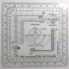
- Risk Estimate Distances for common artillery pieces
- Coordinate Plotting for 1:25,000, 1:50,000, and 1:100,000 scale maps
- Compass rose in degrees and mils
- The tool is printed on 30 mil plastic stock with a protective coating. This makes it about the thickness and stiffness of a credit card. Its 33% thicker than the standard military issue version, so its less likely to be bent or broken when you need to use it.
- Rounded corners keep it from wearing holes in your pockets. It's the size of a music CD, so it stores in more places.
Risk Estimate Distances (REDs) take into account the bursting radius of particular munitions and the characteristics of the delivery system and associates this combination with a percentage for the probability of incapacitation of soldiers at a given range. The RED-combat (or MSD-training) is defined as the minimum distance friendly troops can approach the effects of friendly fires without suffering appreciable casualties of 0.1% or higher probability of incapacitation.
This tool has concentric range rings for danger areas of mortar and artillery systems. Placing the crosshairs on a target allows maneuver units to see how close they can get to where rounds are impacting and still be safe. This allows fire supporters and ground commanders to plan fires (the term used for indirect systems like mortars, artillery, missiles and ordinance from aircraft) on the objective and ensure consistent fires on the enemy as friendly forces move on the battlefield. This is called echeloning of fires and a more detailed explanation can be found in FM 3-90.2.
There are concentric range rings for standing posture REDs for 60mm, 81mm, 120mm mortars and 105mm and 155mm HE Howitzer rounds. There is a set of rings for 1:25,000 scale maps and another for 1:50,000 scale maps.
The other aspects of the tool are an improved version of the Graphic Training Aid 5-2-12 Coordinate Scale and Protractor used by United States and NATO military forces around the world. By using a slot on one side of the tool for access to the map, the tool can be more compact than the traditional GTA tool. The 1:100,000 scale now spans 5km grid lines, making it much more usable. The overall dimensions of the tool have been reduced so that it is the size of a music CD, easily fitting into a pocket or any slot where you could store a CD.
The inner protractor is marked in degrees and the outer protractor is in mils.
Shipping and Returns
- We offer tracked shipping on all orders. Tracking information will be shared as soon as the order is dispatched.
- Please check the delivery estimate before adding a product to the cart. This is displayed for every product on the website.
- Available shipping methods and charges will be displayed at the time of checkout, depending on your exact location.
- All customers are entitled to a return window of 14 days, starting from the date of delivery of the product(s).
- Customers are advised to read our return policy for details of the return process, eligibility, refunds as well as cancellations or exchanges.
- In case of any issues or concerns about Shipping or Returns, please contact us and we will be happy to help.
MapTools.
MapTools Risk Estimate Distances (Reds) Coordinate Grid R...
£50.08
£83.47